Locating NTS Map Sheets
Locating the NTS map sheet that covers the area you need is straight-forward. You can use the NTS index maps available via the CanMaps.com homepage to identify a specific area, which is identified using the following system:
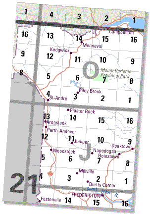
Each area defined by dark grey lines is given a dark grey number (number 21 in the diagram). This is the first element in an NTS map number.
This dark grey extent is divided into 16 smaller areas defined by lighter grey lines; each of these 16 areas is labelled with a light grey letter (O and J, in the diagram). The lettering begins in the southeast (lower right-hand) corner and zigzags to the northeast (upper right-hand) corner. The letter is the second element in an NTS map number for a 1/250 000 map.
This lighter grey extent is divided into 16 areas defined by fine black lines; each of these 16 areas is labelled with a black number (1 to 16). The numbering begins in the southeast (lower right-hand) corner and zigzags to the northeast (upper right-hand) corner. This is the final element in an NTS map number for a 1/50 000 map.
Note that certain maps do not conform to the regular NTS grid. These non-conforming maps have extended or reduced limits to accommodate the extent of the landmass and maintain contiguous areas. Reduced limits remove large extents that show only water and preserve areas that show land. Non-conforming maps help make the National Topographic System more efficient. Generally, non-conforming map sheets can be identified by their irregular lines on the grid; however, some non-conforming 1/250 000 maps are identified by a light/dark pattern of lines and repositioned labels.