Map Scale
What is Scale?
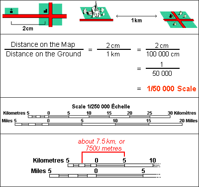
Answer: Maps are made to scale. Scale refers to the relationship between distance on a map and the corresponding distance on the ground. At a scale of 1/50 000 for example, one unit of measure on the map represents 50 000 equivalent units of measure on the ground. Medium-scale maps (e.g. 1/50 000) cover smaller areas in greater detail, whereas smaller-scale maps (e.g. 1/250 000) cover large areas in less detail.
What scale do I need?
Answer: A 1/250 000 scale map gives a general overview of a large area and is a perfect guide for pre-trip planning. It covers an area of approximately 8 000 square kilometres or 160 km x 110 km, and depicts numerous aspects of the terrain. Refer to the map detail and natural landmarks to guide yourself through unfamiliar areas.
A 1/50 000 scale map is highly detailed and covers an area of approximately 1 100 square kilometres or 40 km x 28 km. It shows vegetation, cultural information, approved names (toponymy), land elevation and water bodies, in great detail.
Note: A 1/250 000 scale map covers the same area as sixteen 1/50 000 scale maps.
Reading Distances on a Map
Use the Scale Bar found at the bottom of every National Topographic Systen (NTS) map to determine distances between points or along lines on the map sheet.
Use the secondary division on the left of the Scale Bar for measuring fractions of a kilometre. The measurement indicated in the above image is about 7.5 kilometres or 7 500 metres.