Map Projections: UTM
Map Projections
Because the Earth is a sphere, any representation of its surface on a flat sheet of paper involves distortion. This distortion is relatively insignificant for maps showing small parts of the Earth, such as city maps, but quite considerable for maps of whole countries or continents.
The decision facing a map-maker, therefore, is not whether to have a distortion on a map, but what type of distortion. Over the centuries, various geometrical schemes have been worked out for representing the curved surface of the Earth on map sheets; these schemes are known as map projections. All projections have certain advantages and disadvantages, and the selection of one or the other depends chiefly on the needs of the user.
The size and shape of the country being mapped determines the most suitable projection for its system of topographic maps. Very large countries such as Canada must be divided into strips, usually called zones, which are projected onto a plane in orderly fashion. One such system of strip projection is the Transverse Mercator. It is called tranverse because the strips run north-south rather than east-west along the equator, as in the standard Mercator projection. A special type of Transverse Mercator is the Universal Transverse Mercator (UTM) Projection. The Universal Transverse Mercator Projection is used for the popular National Topographic System (NTS) series at 1/50 000 and 1/250 000 scales. Tied in with this projection is the rectangular grid, a special system for finding and identifying points on maps. All topographic maps also carry the familiar lines of longitude and latitude, but these are not well suited for quick and simple point location and identification.
What is a grid?
Answer: A grid is a pattern of parallel lines intersecting at right angles and forming squares or rectangles; it is used to identify precise positions. To help you locate your position accurately on the surface of the earth (or map sheet), topographic maps have two kinds of referencing systems:
- Geographic: degrees, minutes and seconds (latitude/longitude)
- Universal Transverse Mercator (UTM)
The Universal Transverse Mercator (UTM) Projection
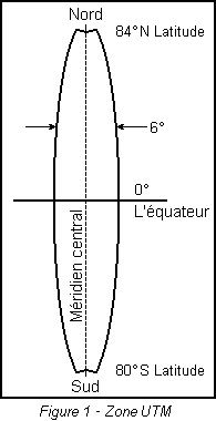
To understand how the projection works, imagine the Earth as an orange, with all geographical features and the parallels and meridians already drawn in. Now imagine taking a knife and, after slicing off small circles at the poles, making a straight north-south cut in the peel of the orange and repeating this north-south cut, at equal intervals, until 60 strips or zones have been detached.
Each of these zones will then form the basis of a separate map projection. The flattening may be envisioned by again considering the detached zone as a strip of orange peel placed on a level surface. By depressing its centre, one could force the peel to flatten until all of it touches the smooth surface. This flattening action results in a slight distortion of the geographical features within the zone, but because the zone is relatively narrow, the distortion is small and may be ignored by most map-users.
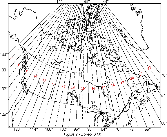
Because the globe is 360° in circumference, a division into sixty vertical zones gives each zone the width of 6° of longitude. By international usage these zones have been numbered 1 to 60. Sixteen of the zones, bearing numbers 7 to 22, cover the entire landmass of Canada.
Once the zone has been flattened onto a level surface it can be divided into a basic set of map sheets of a convenient size. These basic sheets are divided further into sections and each section is published as a map of a larger scale. In Canada this is done to produce the 1/250 000 and 1/50 000 scale maps, which are the two scales of the National Topographic System. By convention, the edges of most maps fall along parallels and meridians. In the far north, where zones are narrow, medium- and small-scale maps may show parts of more than one zone. The important feature of the Universal Transverse Mercator Projection is that the zones are standard and readily identifiable, so that an area may easily be designated as lying within a specific zone.
Continue to find out more about the Universal Transverse Mercator grid at Natural Resources Canada.