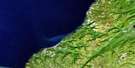
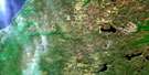
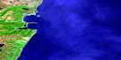
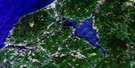
Sydney Satellite Image Map
Download Free Aerial Photo 011K01 at 1:50,000 scale
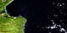
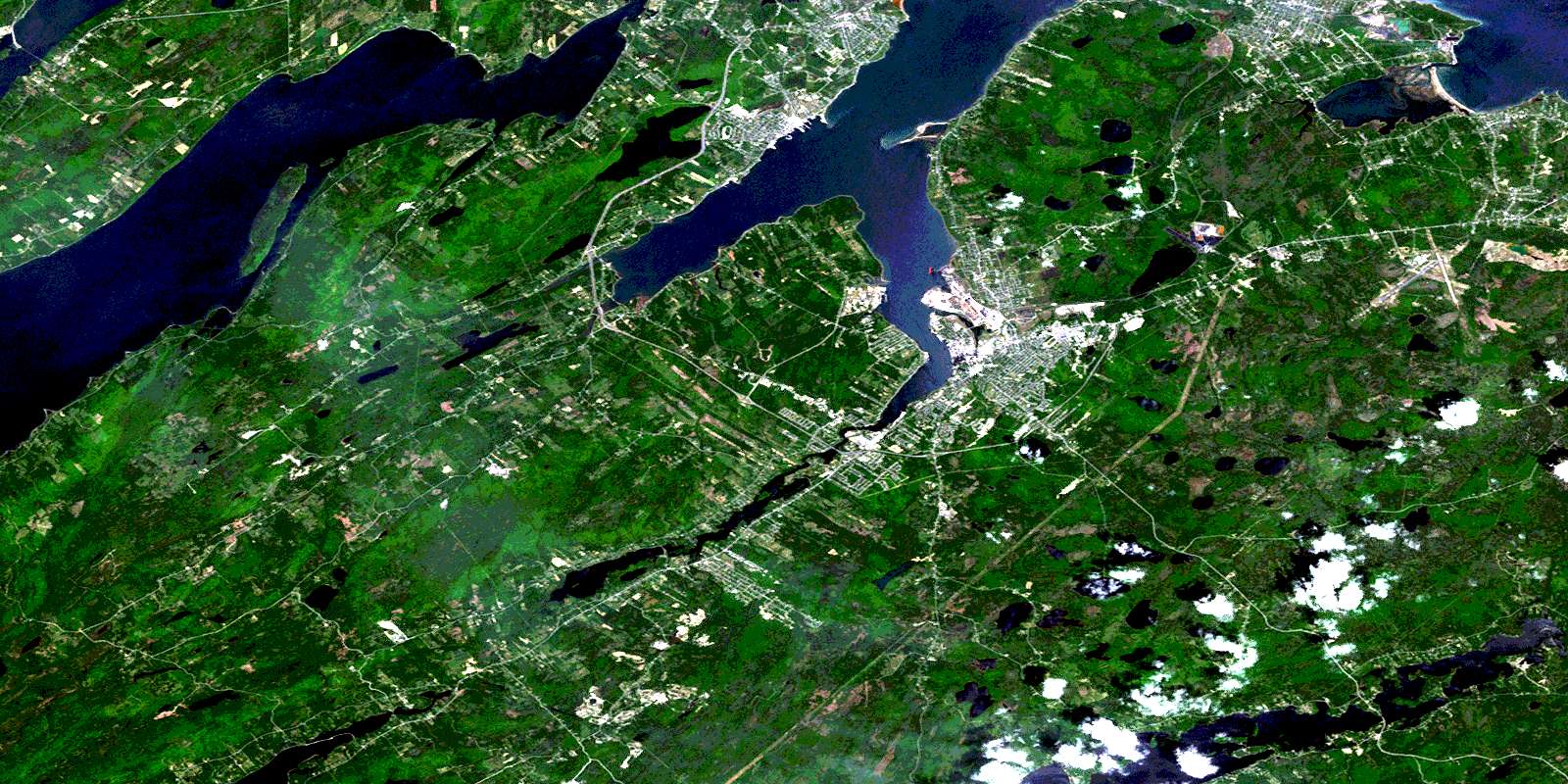
Sydney Satellite Imagery
To view this satellite map, mouse over the air photo on the right.
You can also download this satellite image map for free:
011K01 Sydney high-resolution satellite image map.
Maps for the Sydney aerial map sheet 011K01 at 1:50,000 scale are also available in these versions:
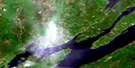
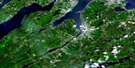
Sydney Surrounding Area Aerial Photo Maps
 |
 |
||
 |
 |
 |
|
 |
 |
 |
|
 |
 |
 |
 |
© Department of Natural Resources Canada. All rights reserved.
Sydney Gazetteer
The following places can be found on satellite image map 011K01 Sydney:
Sydney Satellite Image: Bays
Almon CreekBall Creek
Balls Creek
Barachois Cove
Barachois Creek
Barrachois Harbour
Barrington Cove
Big Bay
Bridgeport Basin
Bridgeport Cove
Campbell Cove
Crawley Creek
Crawleys Creek
Deadman Cove
DesBarres Cove
East Bay
Fergusons Cove
Fishery Cove
Forbes Cove
Georges River Inlet
Gillis Cove
Indian Bay
Keating Cove
Laffins Cove
Leech Creek
Leitches Creek
Lingan Bay
Lloyd Cove
MacDougalls Cove
MacLeans Bay
MacLellans East Bay
MacLellans West Bay
Marys Cove
McKinnons Bay
Meloney Creek
Ministers Cove
Mirror Cove
Morley Bay
Muddy Hole
Muggah Creek
Nichols Cove
North West Arm
Oyster Cove
Rudderham Creek
Saunders Cove
Shanty Cove
Smelt Cove
South Arm
Sydney Harbour
Timmons Cove
Watson Creek
Watsons Creek
Wentworth Creek
Sydney Satellite Image: Beaches
Christies BeachCrooked Beach
East Bay Sand Bar
Kelly Beach
Kellys Beach
Lingan Beach
Long Island Barachois
MacNeils Beach
MacSweens Beach
McNeil Beach
Neil Beach
Nelgah Beach
Northwest Bar
Southeast Bar
The Barrachois
Watsons Beach
Sydney Satellite Image: Capes
Allen PointAlmon Point
Almons Point
Amelia Point
Battery Point
Brian Point
Brickyard Point
Browners Point
Burchells Point
Burkes Point
Campbell Point
Carmichaels Point
Chapel Point
Chapel Point
Codnor Point
Daly Point
David Head
Davys Head
Dixon Point
Dobsons Point
Dougall Point
Duncan Head
Fergusons Point
Groves Point
Hornes Point
Indian Point
Jackson Point
Jacksons Point
Jessomes Point
Jessop Point
Joes Point
Keating Point
Limestone Point
Liscomb Point
Little Head
MacDonalds Point
MacDougalls Point
MacLeans Point
Masons Point
McGillivray Point
McLean Point
McLean Point
Mines Point
Money Point
Moore Point
Morrisons Point
Nichols Point
North Head
Petrie Point
Petries Point
Petries Point
Point Edward
Roderick Head
Rudderham Point
Shawfield Point
Shingle Point
Stubbert Point
The Clay Bank
Timmons Point
Watsons Point
Young Point
Youngs Point
Sydney Satellite Image: Channels
Great Bras d'OrSt. Andrew Channel
St. Andrews Channel
St. Andrew's Channel
Sydney Satellite Image: Falls
Gillis Lake FallsSydney Satellite Image: Geographical areas
Cape BretonVictoria
Sydney Satellite Image: Indian Reserves
Caribou Marsh 29Membertou 28B
Sydney 28A
Sydney Indian Reserve 28B
Sydney Satellite Image: Islands
Boularderie IslandCampbells Island
Cape Breton Island
Goat Island
Île du Cap-Breton
Little Island
Long Island
MacNeils Island
Mainwaring Island
Mouse Island
Round Island
Sangaree Island
Seal Islands
Spencers Island
Sydney Satellite Image: Lakes
Big PondBig Pond
Black Lake
Blackett Lake
Blacketts Lake
Boutellier Lake
Bras d'Or Lake
Bray Lake
Browns Lake
Butler Lake
Campbell Lakes
Campbell Pond
City Reservoir
Cossitt Lake
Cranberry Lake
Cranberry Lake
Cranberry Pond
Curry Lake
Cusack Lake
Dalem Lake
Deadman Lake
Dodd Lake
Ducker Lake
Dumaresq Lake
Edwards Pond
Ferguson Lake
Fergusons Lake
First Dodds Lake
Forester Lake
Forresters Lake
Front Lake
Gammell Lake
George Lake
Georges Lake
Georges River Barachois
Gilholmes Lake
Gillies Lake
Gillis Lake
Gillis Lake
Gillis Lake
Glen Lake
Gouthro Lake
Grand Lake
Hay Lake
Inglis Lake
Joe Lake
Joes Lake
Johnson Lake
Keefe Lake
Kehoe Lake
Kilkenny Lake
Lily Lake
Lily Lake
Ling Lake
Little Gillis Lake
Little Hay Lake
Little Pond
Loon Lake
MacAulays Lakes
MacDonald Lake
Macdonald Lake
MacDonald Lake
MacDonalds Lake
MacDonalds Lake
MacEachern Lake
MacInnis Pond
MacIsaacs Lake
MacKeigan Lake
MacKinnons Ponds
MacLeans Lake
MacMullin Lake
MacMullin Lake
MacNeil Lake
Marsh Lake
McAdam Lake
McAdams Lake
McAulay Lake
McAulay Lakes
McInnis Lake
McIsaac Lake
McKeigan Lake
McMullen Lake
McNeil Lake
McPherson Lake
Middle Lake
Mill Lake
Morrison Lake
Morrison Lake
Morrison Lake
Morrisons Lake
Mud Lake
O'Neil Lake
Patterson Lake
Pattersons Lake
Peter Lake
Petrie Lake
Petries Lake
Pottle Lake
Power Lake
Roach Lake
Sandy McLeod Lake
Scotch Lake
Second Dodds Lake
Steeles Pond
Stump Lake
Waterford Lake
Sydney Satellite Image: Military areas
Champ de tir SydneySydney Range
Sydney Satellite Image: Mountains
Boisdale HillsCampbells Hill
Conns Hill
Coxheath Hills
East Bay Hills
Goat Hill
Kelly Hill
Mount Cameron
Sydney Satellite Image: Major municipal/district area - major agglomerations
Cape BretonVictoria
Sydney Satellite Image: Conservation areas
Barachois Provincial ParkBarrachois Provincial Park
Dalem Lake Provincial Park
Dominion Beach Provincial Park
Groves Point Provincial Park
Mira River Provincial Park
Petersfield Provincial Park
Sydney Satellite Image: Rivers
Aconi (Fifes) BrookAconi Brook
Barachois Brook
Barachois Creek
Battlements Brook
Big Brook
Black Brook
Black Brook
Black Brook Mira
Blackbottom Brook
Bradford Brook
Cadegan Brook
Cadogan Brook
Campbell Brook
Caribou Marsh Brook
Crawley Creek
Currys Brook
Dan Morrisons Brook
Darby Brook
Dutch Brook
Eoins Brook
Ferguson Brook
Fifes Brook
Frenchvale Brook
George River
Georges River
Gillies Brook
Gillis Brook
Gillis Brook
Graces Brook
Gracie Brook
Grantmire Brook
Howies Brook
Irish Brook
Johnston Brook
Johnstons Brook
Kehoe Brook
Kilkenny Lake Brook
Leitches Brook
Leitches Creek
Limestone Brook
Little Brook
Long Swamp Brook
MacAskills Brook
Macbeth Brook
MacDonalds Brook
MacIntosh Brook
Macintosh Brook
MacKay Brook
MacKeigan Brook
MacKenzie Brook
MacSweens Brook
Malcolm Brook
Malcolms Brook
McAdams Brook
McAskill Brook
McCall Brook
McColl Brook
McKeagan Brook
McKenzie Brook
McKinnon Brook
McKinnons Brook
McLennan Brook
McLeod Brook
Meadows Brook
Mill Brook
Mill Brook
Mira River
Morrison Brook
Northwest Brook
Portage Brook
Prime Brook
Ratchford Brook
Renwick Brook
Reservoir Brook
Schoolhouse Brook
Smelt Brook
Southwest Brook
Spencer Brook
Spencers Brook
Spruce Brook
Sydney River
Tobins Brook
Wash Brook
Waterford Brook
Watson Creek
Wentworth Creek
Woodbine Brook
Young Brook
Youngs Brook
Sydney Satellite Image: River features
Salmon HoleSydney Satellite Image: Shoals
Barachois BarLime Rock
McVarish Shoal
Seal Reefs
Seal Rock
Sydney Satellite Image: Towns
Old BridgeportSydney Satellite Image: Unincorporated areas
Albert BridgeAshby
Ball Creek
Balls Creek
Barachois
Barachois Harbour
Barrachois
Barrachois Harbour
Beechmont
Beechmont North
Belgiumtown
Big Bank
Black Brook
Blackett Lake
Blacketts Lake
Boularderie East
Boularderie West
Bras d'Or
Brickyard Road
Caribou Marsh
Centreville
Centreville Reserve Mines
Colonial
Coxheath
Dominion
Dutch Brook
East Bay
East Bay North Side
East Slope
Edwardsville
Frenchvale
Front Lake
Gannon Road
Gardiner
Gardiner Mines
Georges River
Gibbon
Gilliesville
Gillis Lake
Gillisville
Grand Lake Road
Groves Point
Hardwood Hill
Hills Road
Hillside
Hillside Boularderie
Horne Road
Hornes Road
Horns Road
Howie Centre
Ironville
Jacksonville
Jefferson
Jefferson Siding
Kilkenny Lake
Kytes Hill
Leitch Creek Station
Leitches Creek
Leitches Creek Station
Lingan
Lingan Road
Little Bras d'Or
Long Island Main
McAdam Lake
McAdams Lake
McKenzie East Bay
McLeanville
McLeods Crossing
Meadows Road
Mira Road
Morrison Road
New Harris
New Harris Settlement
New Victoria
New Waterford
North Sydney
North West Arm
North West Arm
Northside East Bay
Oakfield
Point Edward
Portage
Portage East Bay
Prime Brook
Rear Balls Creek
Rear Boisdale
Rear of Ball Creek
Reserve Mines
Reserve Rows
River Ryan
Sangaree
Scotch Lake
Scotchtown
South Bar
Southside Boularderie
Steele Lake
Sydney
Sydney Forks
Sydney Mines
Sydney River
Tomkinsville
Upper Leitch Creek
Upper Leitches Creek
Upper North Sydney
Victoria Junction
Victoria Mines
Watson
Watson Station
Westmount
Whitney Pier
Sydney Satellite Image: Low vegetation
Big MarshMacSweens Marsh
Pattersons Marsh
Wolfes Marsh
Sydney Satellite Image: Villages
Leitch CreekSouth Bar of Sydney River
© Department of Natural Resources Canada. All rights reserved.
