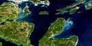
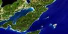
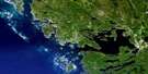
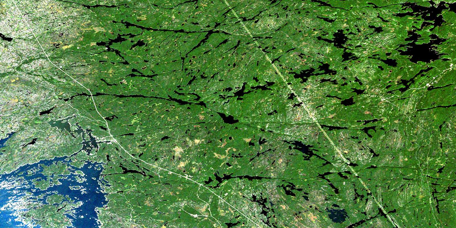
Pointe Au Baril Station Satellite Image Map
Download Free Aerial Photo 041H09 at 1:50,000 scale
Pointe Au Baril Station Satellite Imagery
To view this satellite map, mouse over the air photo on the right.
You can also download this satellite image map for free:
041H09 Pointe Au Baril Station high-resolution satellite image map.
Maps for the Pointe Au Baril Station aerial map sheet 041H09 at 1:50,000 scale are also available in these versions:
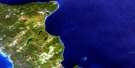
Pointe Au Baril Station Surrounding Area Aerial Photo Maps
 |
 |
 |
 |
 |
 |
 |
|
 |
 |
||
 |
 |
 |
© Department of Natural Resources Canada. All rights reserved.
Pointe Au Baril Station Gazetteer
The following places can be found on satellite image map 041H09 Pointe Au Baril Station:
Pointe Au Baril Station Satellite Image: Bays
Aldrich CoveBaie Georgienne
Bayfield Harbour
Bayfield Inlet
Bayfield Inlet
Bennetts Bay
Big Bay
Big Deep Bay
Bolger Bay
Borrows Bay
Buchus Bay
Chutes Bay
Deep Bay
Driftwood Bay
Duck Bay
Georgian Bay
Greens Bay
Harrisons Bay
Haslam Bay
Haywards Bay
Hogsback Bay
Holts Bay
Hopewell Bay
Laura Bay
Lawson Bay
LeBlanc Bay
Long Arm
Magnetawan Bay
Moonlight Bay
Nares Inlet
Nares Inlet
Oberlin Bay
Paddys Bay
Parkers Bay
Pelham Cove
Pike Bay
Portage Bay
Robertsons Bay
Sandy Bay
Shabbots Bay
Shanty Bay
Shawanaga Inlet
Skerryvore Bay
Slip Bay
Sturgeon Bay
Summerville Bay
Taylor Bay
Toronto Bay
Tracy Bay
Truax Bay
Wajuwebo Bay
Whitestone Bay
Pointe Au Baril Station Satellite Image: Beaches
Ketchums BeachMill Beach
Straubs Beach
Pointe Au Baril Station Satellite Image: Capes
Abbott PointBlanche Point
Creswells Point
Eberles Point
Eureka Point
Gowland Point
Graves Point
Hagartys Point
Haggart Point
Harts Point
Hazel Point
Hemlock Point
Hogarth Point
Kelleys Point
Kelly Point
Kitsilano Point
Klokaloo Point
Lookout Point
MacRaes Point
Macys Point
Marjorie Point
Marks Point
Marshall Point
McGibbon Point
McLean Point
Millers Point
Mortons Point
Parwood Point
Pine Ridge Point
Point Comfort
Porcupine Point
Sedgewick Point
Selma Point
Skram Point
Straubs Point
Sunset Point
Toggle Point
Trails End Point
Truax Point
Violet Point
Walkerville Point
Pointe Au Baril Station Satellite Image: Channels
Back ChannelBottrells Narrows
Brignall Banks Narrows
Deadmans Narrows
Hemlock Channel
Indian Narrows
Kitsilano Channel
Middle Channel
Parkers Narrows
Pointe au Baril Channel
S Turn Channel
Skerryvore Channel
Sneak Channel
Pointe Au Baril Station Satellite Image: Falls
Whitestone ChutesPointe Au Baril Station Satellite Image: Geographical areas
BrownBurpee
Burton
Carling
East Burpee
Ferguson
Hagerman
Harrison
McKenzie
Parry Sound
Shawanaga
Wallbridge
Pointe Au Baril Station Satellite Image: Indian Reserves
Magnetawan 1Magnetawan Indian Reserve 1
Naiscoutaing 17A
Naiscoutaing Indian Reserve 17A
Réserve indienne Magnetawan 1
Réserve indienne Naiscoutaing 17A
Réserve indienne Shawanaga 17
Réserve indienne Shawanaga 17B
Shawanaga 17
Shawanaga 17B
Shawanaga Indian Reserve 17
Shawanaga Indian Reserve 17B
Pointe Au Baril Station Satellite Image: Islands
Abbott IslandAddoms Island
Amy Island
Arbor Vitae Island
Aristenesos Island
Armida Island
Barclay Island
Bedwell Island
Bellavista Island
Belle Island
Bien Venue Island
Bigwood Island
Birch Island
Birchard Island
Black Bass Island
Blue Chip Island
Blue Chips Island
Bobs Island
Bogart Island
Bonnie Island
Boys Island
Bruckland Island
Burnt Island
Burnt Island
Carfrae Island
Caroline Island
Carolyn Island
Castor Island
Champlain Monument Island
Chowne Island
Clare Island
Claytonwood Island
Deadmans Island
Dorets Island
Double Island
Dundurn Island
Eaglenest Island
Edna Island
Eldorado Island
Electric Island
Emerald Island
Empress Island
Fairwood Island
Four Winds Island
Gillanders Island
Good Island
Grave Island
Green Island
Griffins Island
Grindstone Island
Groundhog Island
H.A. Gray Island
Harris Island
Harrisons Island
Hearts Content Island
High Pine Island
Hopewell Island
Horseshoe Island
Huckleberry Island
Hydes Island
Isaacs Island
Jergens Island
Kaavis Island
Kaawis Island
Kathalan Island
Kenilworth Island
Ketchums Island
Kishkadena Island
Kyle Island
Lampey Island
Lauder Islands
Leonard Island
Little Otakesing Island
Lloyd Island
MacKenzie Island
Mackey Island
Macklin Island
Maryrose Island
Maskinonge Island
Mayne Island
McConkey Island
Meenahaga Island
Moffat Island
Mosley Island
Nadeau Island
Nepahwin Island
Ojibway Island
Oldfield Island
Olive Island
Oliver Island
Olver Island
Opechee Island
Orchard Island
Otakesing Island
Ozone Island
Passage Island
Pavis Island
Pentecost Island
Pittsburg Island
Pollard Island
Pollux Island
Poplar Island
Price Island
Puswawa Island
Raspberry Island
Rathlyn Island
Richards Island
Rogers Island
Ropers Island
Sandy Hook
Sasega Island
School House Island
Scroggies Island
Shawanaga Island
Sidney Island
Skunk Island
Squirecrest Island
Squires Island
Stairs Island
Telfer Island
Thallata Island
Thorburn Island
Tonches Island
Tracy Island
Trim Tree Island
Turkey Island
Turnbull Island
Turning Island
Underwood Island
Vernon Island
Victoria Island
Wanesching Island
Wedding Cake Island
White Island
Winona Island
Woodlands Island
Young Island
Zephyr Island
Zock Island
Pointe Au Baril Station Satellite Image: Lakes
Apple LakeApple Lake
Argue Lake
Bat Lake
Bear Lake
Bear Lake
Bell Lake
Big Lake
Birch Lake
Bird Lake
Black Lake
Black Oak Lake
Blue Lake
Bolger Lake
Boundary Lake
Boyd Lake
Brewery Lake
Brophys Lake
Burnt Lake
Burnt Lake
Carson Lake
Cat Lake
Clear Lake
Cranberry Lake
De Bois Lake
De Volve Lake
Doctor Lake
Dogfish Lake
Evans Lake
Fox Lake
Fraud Lake
Giroux Lake
Gooseneck Lake
Gordon Lake
Grandma Lake
Grandpa Lake
Granite Lake
Granite Lake
Green Island Lake
Grouse Lake
Gull Lake
Harris Lake
Headquarters Lake
Hogan Lake
Horseshoe Lake
Island Lake
Kashegaba Lake
Kibeong Lake
Lac Huron
Lac La Vallée
Lake Huron
Little Carson Lake
Little Gooseneck Lake
Little Shawanaga Lake
Little Wilson Lake
Littles Back Lake
Littles Lake
Log Lake
Lone Tree Lake
Lonetree Lake
Long Lake
Long Moose Lake
Loon Lake
Lorimer Lake
Lost Tower Lake
Mallard Lake
Maple Lake
McCabes Lake
McCormicks Pond
Miner Lake
Miskokway Lake
Moose Lake
Mud Lake
Munsons Lake
Myrtle Lake
Naiscoot Lake
Nine Mile Lake
Nine-mile Lake
Northern Pike Lake
Owl Lake
Oxbow Lake
Paddy Gordon Lake
Partridge Lake
Pike Lake
Porcupine Lake
Rainy Lake
Raven Lake
Rock Island Lake
Round Lake
Round Lake
Scott Lake
Secret Lake
Seesee Lake
Shawanaga Lake
Silver Bass Lake
Six Mile Lake
Skunk Lake
Snakeskin Lake
Snowshoe Lake
Spectacle Lake
Sucker Lake
Sullivan Lake
Taylors Lake
Tea Lake
The Big Lake
The Top Lake
Timber Wolf Lake
Tower Lake
Trout Lake
Trout Lake
Truax Lake
Turtle Lake
Upper Marsh Lake
Wahwashkesh Lake
Wallace Lake
Wassagami Lake
West Taylors Lake
Whites Lake
Wilson Lake
Wiwassasegen Lake
Wolf Lake
Pointe Au Baril Station Satellite Image: Mountains
The HogsbackPointe Au Baril Station Satellite Image: Other municipal/district area - miscellaneous
CarlingGeorgian Bay North Archipelago
Georgian Bay South Archipelago
Hagerman
Magnetawan
McDougall
The Archipelago
Whitestone
Pointe Au Baril Station Satellite Image: Conservation areas
Ferguson Township White Pine Forest Conservation ReserveIsland Lake Forest and Barrens Conservation Reserve
Naiscoot Forest Conservation Reserve
Oxbow Lake Forest Conservation Reserve
Point au Baril Forests and Wetlands Conservation Reserve
Round Lake Provincial Nature Reserve
Shawanaga Lake Conservation Reserve
Sturgeon Bay Provincial Park
Wahwashkesh-Naiscoot Conservation Reserve
Pointe Au Baril Station Satellite Image: Rapids
Thirty Dollar RapidsThree Snye Rapids
Pointe Au Baril Station Satellite Image: Rivers
Blair CreekBolger Creek
Briar Creek
Dogfish River
Farm Creek
Fivemile River
Gooseneck Creek
Harris River
Loon Creek
Magnetawan River
Munsons Creek
Naiscoot River
Paddys Creek
Sauder Creek
Shawanaga River
Snakeskin Creek
South Branch
Sucker Creek
Sucker Creek
Whitestone River
Pointe Au Baril Station Satellite Image: Road features
Indian PortagePointe Au Baril Station Satellite Image: Shoals
Bald RockButton Rocks
Carey Rocks
Clamshell Rock
Dans Rocks
Duke Rock
Gull Rock
Jane Rock
Jessies Rock
Johnny Rock
Josephine Rocks
Julia Reef
Little Pickerel Rock
Loaf Rock
MacRae Rock
Mary Rock
McGregor Rock
Millers Rocks
Moby Dick
North Pickerel Rock
O'Connor Rocks
Peak Stone Rock
Pickerel Rocks
Pirie Rocks
Pym Rock
Register Rock
Register Shoal
Rigg Rock
Ripple Rock
Robertsons Shoal
Squaw Rock
Sultan Rock
Torran Rocks
Turning Rocks
Turtleback Rock
Vivian Rocks
Whitsun Rock
Pointe Au Baril Station Satellite Image: Springs
Porcupine SpringPointe Au Baril Station Satellite Image: Unincorporated areas
ArdbegBayfield
Bayfield Inlet
Boakview
Bolger
Bolger Bridge
Burton
Harris Lake
Manbert
Naiscoot
Niweme
North Magnetawan
Ojibway Island
Pointe au Baril Station
Shawanaga
Shawanaga Landing
Skerryvore
South Mag
South Maganatawan
South Magnetawan
Wahwashkesh
Wahwashkesh Landing
© Department of Natural Resources Canada. All rights reserved.
