Grady Harbour Topo Map Online
Download Free Topo Map Sheet 013H16 at 1:50,000 scale
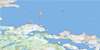
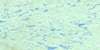
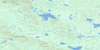
013H16 Grady Harbour Topo Map
To view this map, mouse over the map preview on the right.
You can also download this topo map for free:
013H16 Grady Harbour high-resolution topo map image.
Maps for the Grady Harbour topo map sheet 013H16 at 1:50,000 scale are also available in these versions:
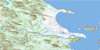
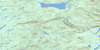
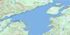
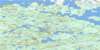
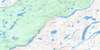
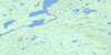
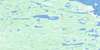
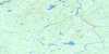
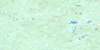
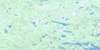
Grady Harbour Surrounding Area Topo Maps
 |
 |
 |
 |
 |
 |
 |
 |
 |
 |
 |
 |
 |
 |
 |
 |
© Department of Natural Resources Canada. All rights reserved.
Grady Harbour Gazetteer
The following places can be found on topographic map sheet 013H16 Grady Harbour:
Grady Harbour Topo Map: Bays
Back CoveBlack Island Harbour
Grady Harbour
Shoal Cove
Watering Cove
Grady Harbour Topo Map: Capes
Cape NorthCape St. Nicolas
White Point
White Point
Grady Harbour Topo Map: Channels
Pigeon TickleGrady Harbour Topo Map: Islands
Black IslandCross Island
Flat Islands
Grady Island
Hare Island
Little Grady Island
Offer Wolf Island
Pigeon Island
Stunk Island
The Wolves
Wolf Islands
Grady Harbour Topo Map: Shoals
East Gannet RockGrady Reef
Halfway Rock
High-rat Bank
Johnny Paul Rock
Mad Moll
Meade Shoal
Grady Harbour Topo Map: Unincorporated areas
Grady HarbourNorth Cove

© Department of Natural Resources Canada. All rights reserved.
013H Related Maps:
013H Cartwright013H01 No Title
013H02 No Title
013H03 No Title
013H04 No Title
013H05 No Title
013H06 Paradise River
013H07 No Title
013H08 Porcupine Bay
013H09E Sand Hill Cove
013H09W Sand Hill Cove
013H10 Hare Harbour
013H11 Cartwright
013H12 Barron Lake
013H13E North River
013H13W North River
013H14E Trunmore Bay
013H14W Trunmore Bay
013H15E Packs Harbour
013H15W Packs Harbour
013H16W Grady Harbour
