Joint Lake Topo Map Online
Download Free Topo Map Sheet 053L06 at 1:50,000 scale
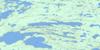
053L06 Joint Lake Topo Map
To view this map, mouse over the map preview on the right.
You can also download this topo map for free:
053L06 Joint Lake high-resolution topo map image.
Maps for the Joint Lake topo map sheet 053L06 at 1:50,000 scale are also available in these versions:
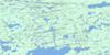
Joint Lake Surrounding Area Topo Maps
 |
 |
 |
 |
 |
 |
 |
 |
 |
 |
 |
 |
 |
 |
 |
 |
© Department of Natural Resources Canada. All rights reserved.
Joint Lake Gazetteer
The following places can be found on topographic map sheet 053L06 Joint Lake:
Joint Lake Topo Map: Bays
Beatty BayCoulter Bay
Wasakamak Bay
Joint Lake Topo Map: Capes
Birch PeninsulaCox Point
Gillespie Point
Harris Peninsula
Ritchie Point
Joint Lake Topo Map: Channels
Wapeekamasink NarrowsWright Narrows
Joint Lake Topo Map: Indian Reserves
Wesha Kijay WasagamachJoint Lake Topo Map: Lakes
Amos LakeAswapiswanan Lake
Beaver Hill Lake
Beaverhill Lake
Glen Small Lake
Joint Lake
Joseph Sinclair Lake
Kiask Lake
Namaykos Lake
Stewart Anderson Lake
Touchwood Lake
Joint Lake Topo Map: Mountains
Norman Wilson EskerJoint Lake Topo Map: Rapids
Kakwu RapidsMichiskun Rapids
Taylor Rapids
Joint Lake Topo Map: Rivers
Bolton RiverJoint River
Mink River
Porcupine Creek
Wapawukaw River

© Department of Natural Resources Canada. All rights reserved.
053L Related Maps:
053L Oxford House053L01 Mistuhe Lake
053L02 Kakeenukamak Lake
053L03 Opom Lake
053L04 Nikik Lake
053L05 Bolton Lake
053L06 Joint Lake
053L07 Kanuchuan Rapids
053L08 Murray Lake
053L09 Gods Lake
053L10 Vermilyea Lake
053L11 Munro Lake
053L12 Windy Lake
053L13 Carghill Island
053L14 Oxford House
053L15 Knee Lake
053L16 Mcivor Lake
