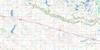
Birtle Topo Map Online
Download Free Topo Map Sheet 062K06 at 1:50,000 scale
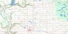
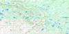
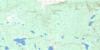
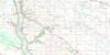
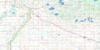
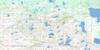
062K06 Birtle Topo Map
To view this map, mouse over the map preview on the right.
You can also download this topo map for free:
062K06 Birtle high-resolution topo map image.
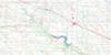
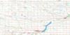
Maps for the Birtle topo map sheet 062K06 at 1:50,000 scale are also available in these versions:
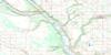
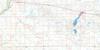
Birtle Surrounding Area Topo Maps
 |
 |
 |
 |
 |
 |
 |
 |
 |
 |
 |
 |
 |
 |
 |
 |
© Department of Natural Resources Canada. All rights reserved.
Birtle Gazetteer
The following places can be found on topographic map sheet 062K06 Birtle:
Birtle Topo Map: Hydraulic construction
Birtle DamBirtle Topo Map: Indian Reserves
Birdtail Creek 57Birtle Topo Map: Lakes
Falloons LakeGrand Lac
Hooper Lake
Hoopers Lake
Birtle Topo Map: Mountains
Cleghorn HillBirtle Topo Map: Other municipal/district area - miscellaneous
ArchieBirtle
Ellice
Moosomin No. 121
Rocanville No. 151
Spy Hill No. 152
Birtle Topo Map: Conservation areas
Upper Assiniboine Wildlife Management AreaBirtle Topo Map: Plains
Stony PlainsWattsview Plains
Birtle Topo Map: Rivers
Assiniboine RiverBeaver Creek
Birdtail Creek
Brennand Creek
Brennand Creek
Hotonka Creek
Minnewasta Creek
Qu'Appelle River
Qu'Appelle River
Scissor Creek
Scissor Creek
Snake Creek
Birtle Topo Map: Towns
BirtleBirtle Topo Map: Unincorporated areas
BeulahBirdtail Sioux
McAuley
Treat
Victor
Wattsview
Birtle Topo Map: Valleys
Solomons GullyBirtle Topo Map: Low vegetation
Chambers SloughSeales Slough
Birtle Topo Map: Villages
St. LazareSt-Lazare

© Department of Natural Resources Canada. All rights reserved.
