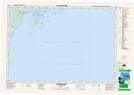
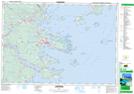
Maps showing Currie Cove, Lunenburg, Nova Scotia
Currie Cove is a Bay located in Lunenburg, Nova Scotia and has an elevation of 8 meters.
- Latitude: 44° 15' North (decimal: 44.2500000)
- Longitude: 64° 24' West (decimal: -64.3991666)
- Topography Feature Category: Bay
- Geographical Feature: Cove
- Canadian Province/Territory: Nova Scotia
- Elevation: 8 meters
- Location: Lunenburg
- Atlas of Canada Locator Map: Currie Cove
- GPS Coordinate Locator Map: Currie Cove Lat/Long
Currie Cove NTS Map Sheets