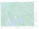
Maps showing Lac Georges, Lac-Devenyns; Matawinie, Quebec
Lac Georges is a Lake located in Lac-Devenyns; Matawinie, Quebec and has an elevation of 431 meters.
- Latitude: 46° 56' 48'' North (decimal: 46.9467062)
- Longitude: 73° 41' 4'' West (decimal: -73.6843059)
- Topography Feature Category: Lake
- Geographical Feature: Lac
- Canadian Province/Territory: Quebec
- Elevation: 431 meters
- Location: Lac-Devenyns; Matawinie
- Atlas of Canada Locator Map: Lac Georges
- GPS Coordinate Locator Map: Lac Georges Lat/Long
Lac Georges NTS Map Sheets