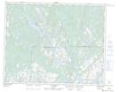
Maps showing Pointe Mousnier, Petit-Mécatina; Minganie, Quebec
Pointe Mousnier is a Cape located in Petit-Mécatina; Minganie, Quebec and has an elevation of 53 meters.
- Latitude: 51° 23' 51'' North (decimal: 51.3975601)
- Longitude: 58° 40' 32'' West (decimal: -58.6754884)
- Topography Feature Category: Cape
- Geographical Feature: Pointe
- Canadian Province/Territory: Quebec
- Elevation: 53 meters
- Location: Petit-Mécatina; Minganie
- Atlas of Canada Locator Map: Pointe Mousnier
- GPS Coordinate Locator Map: Pointe Mousnier Lat/Long
Pointe Mousnier NTS Map Sheets