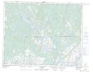
Maps showing Rapides Trout Hall, Petit-Mécatina; Minganie, Quebec
Rapides Trout Hall is a Rapids located in Petit-Mécatina; Minganie, Quebec.
- Latitude: 51° 20' 25'' North (decimal: 51.3403405)
- Longitude: 58° 54' 28'' West (decimal: -58.9077184)
- Topography Feature Category: Rapids
- Geographical Feature: Rapides
- Canadian Province/Territory: Quebec
- Location: Petit-Mécatina; Minganie
- Atlas of Canada Locator Map: Rapides Trout Hall
- GPS Coordinate Locator Map: Rapides Trout Hall Lat/Long
Rapides Trout Hall NTS Map Sheets