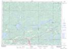
Maps showing The Haystack, Sudbury, Ontario
The Haystack is a Mountain located in Sudbury, Ontario and has an elevation of 283 meters.
- Latitude: 46° 23' 25'' North (decimal: 46.3902777)
- Longitude: 81° 47' 59'' West (decimal: -81.7997222)
- Topography Feature Category: Mountain
- Geographical Feature: Hill
- Canadian Province/Territory: Ontario
- Elevation: 283 meters
- Location: Sudbury
- Atlas of Canada Locator Map: The Haystack
- GPS Coordinate Locator Map: The Haystack Lat/Long