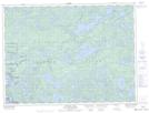
Maps showing Tubman Creek, Rainy River, Ontario
Tubman Creek is a River located in Rainy River, Ontario and has an elevation of 394 meters.
- Latitude: 48° 28' 10'' North (decimal: 48.4694444)
- Longitude: 91° 34' 51'' West (decimal: -91.5808333)
- Topography Feature Category: River
- Geographical Feature: Creek
- Canadian Province/Territory: Ontario
- Elevation: 394 meters
- Location: Rainy River
- Atlas of Canada Locator Map: Tubman Creek
- GPS Coordinate Locator Map: Tubman Creek Lat/Long
Tubman Creek NTS Map Sheets