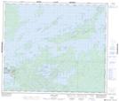
Maps showing Kichenaonan Point, Manitoba
Kichenaonan Point is a Cape located in Manitoba and has an elevation of 187 meters.
- Latitude: 54° 42' 14'' North (decimal: 54.7039000)
- Longitude: 94° 23' 12'' West (decimal: -94.3866999)
- Topography Feature Category: Cape
- Geographical Feature: Point
- Canadian Province/Territory: Manitoba
- Elevation: 187 meters
- Atlas of Canada Locator Map: Kichenaonan Point
- GPS Coordinate Locator Map: Kichenaonan Point Lat/Long
Kichenaonan Point NTS Map Sheets