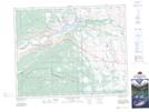
Maps showing Pile of Bones Creek, 24-25-5-W5, Alberta
Pile of Bones Creek is a River located in 24-25-5-W5, Alberta and has an elevation of 1217 meters.
- Latitude: 51° 9' 14'' North (decimal: 51.1538889)
- Longitude: 114° 34' 31'' West (decimal: -114.5752777)
- Topography Feature Category: River
- Geographical Feature: Creek
- Canadian Province/Territory: Alberta
- Elevation: 1217 meters
- Location: 24-25-5-W5
- Atlas of Canada Locator Map: Pile of Bones Creek
- GPS Coordinate Locator Map: Pile of Bones Creek Lat/Long
Pile of Bones Creek NTS Map Sheets