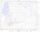
Maps showing Bantry, 5-18-13-W4, Alberta
Bantry is a Unincorporated area located in 5-18-13-W4, Alberta.
- Latitude: 50° 29' 38'' North (decimal: 50.4938888)
- Longitude: 111° 44' 00'' West (decimal: -111.7333332)
- Topography Feature Category: Unincorporated area
- Geographical Feature: Locality
- Canadian Province/Territory: Alberta
- Location: 5-18-13-W4
- Atlas of Canada Locator Map: Bantry
- GPS Coordinate Locator Map: Bantry Lat/Long
Bantry NTS Map Sheets