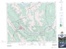
Maps showing Exshaw, 22-24-9-W5, Alberta
Exshaw is a Unincorporated area located in 22-24-9-W5, Alberta and has an elevation of 1319 meters.
- Latitude: 51° 3' 42'' North (decimal: 51.0616666)
- Longitude: 115° 9' 46'' West (decimal: -115.1627777)
- Topography Feature Category: Unincorporated area
- Geographical Feature: Hamlet
- Canadian Province/Territory: Alberta
- Elevation: 1319 meters
- Location: 22-24-9-W5
- Atlas of Canada Locator Map: Exshaw
- GPS Coordinate Locator Map: Exshaw Lat/Long