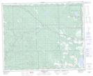
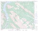
Maps showing Ram River, 39-10-W5, Alberta
Ram River is a River located in 39-10-W5, Alberta and has an elevation of 1154 meters.
- Latitude: 52° 22' 33'' North (decimal: 52.3758333)
- Longitude: 115° 24' 51'' West (decimal: -115.4141666)
- Topography Feature Category: River
- Geographical Feature: River
- Canadian Province/Territory: Alberta
- Elevation: 1154 meters
- Location: 39-10-W5
- Atlas of Canada Locator Map: Ram River
- GPS Coordinate Locator Map: Ram River Lat/Long
Ram River NTS Map Sheets
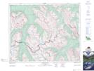
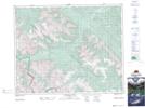
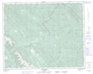
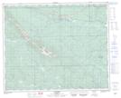
082N16 Siffleur River Topographic Map at 1:50,000 scale
082O13 Forbidden Creek Topographic Map at 1:50,000 scale
083B04 Elk Creek Topographic Map at 1:50,000 scale
083B05 Saunders Topographic Map at 1:50,000 scale
083B06 Crimson Lake Topographic Map at 1:50,000 scale
083C01 Whiterabbit Creek Topographic Map at 1:50,000 scale
082N Golden Topographic Map at 1:250,000 scale
082O Calgary Topographic Map at 1:250,000 scale
083B Rocky Mountain House Topographic Map at 1:250,000 scale
083C Brazeau Lake Topographic Map at 1:250,000 scale