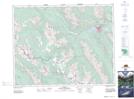
Maps showing Mount Edith, 26-12-W5, Alberta
Mount Edith is a Mountain located in 26-12-W5, Alberta and has an elevation of 2214 meters.
- Latitude: 51° 12' 4'' North (decimal: 51.2011111)
- Longitude: 115° 39' 46'' West (decimal: -115.6627777)
- Topography Feature Category: Mountain
- Geographical Feature: Mount
- Canadian Province/Territory: Alberta
- Elevation: 2214 meters
- Location: 26-12-W5
- Atlas of Canada Locator Map: Mount Edith
- GPS Coordinate Locator Map: Mount Edith Lat/Long