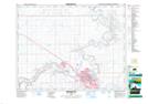
Maps showing Galt Island, 7-13-6-W4, Alberta
Galt Island is a Island located in 7-13-6-W4, Alberta.
- Latitude: 50° 4' 19'' North (decimal: 50.0719444)
- Longitude: 110° 49' 7'' West (decimal: -110.8186111)
- Topography Feature Category: Island
- Geographical Feature: Island
- Canadian Province/Territory: Alberta
- Location: 7-13-6-W4
- Atlas of Canada Locator Map: Galt Island
- GPS Coordinate Locator Map: Galt Island Lat/Long
Galt Island NTS Map Sheets