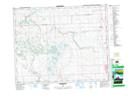
Maps showing Bottrel, 21-28-4-W5, Alberta
Bottrel is a Unincorporated area located in 21-28-4-W5, Alberta and has an elevation of 1255 meters.
- Latitude: 51° 24' 9'' North (decimal: 51.4025000)
- Longitude: 114° 28' 17'' West (decimal: -114.4713888)
- Topography Feature Category: Unincorporated area
- Geographical Feature: Locality
- Canadian Province/Territory: Alberta
- Elevation: 1255 meters
- Location: 21-28-4-W5
- Atlas of Canada Locator Map: Bottrel
- GPS Coordinate Locator Map: Bottrel Lat/Long