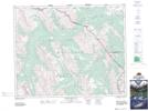
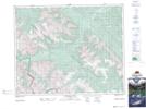
Maps showing Scalp Creek, 32-11-W5, Alberta
Scalp Creek is a River located in 32-11-W5, Alberta.
- Latitude: 51° 43' 51'' North (decimal: 51.7308333)
- Longitude: 115° 33' 9'' West (decimal: -115.5525000)
- Topography Feature Category: River
- Geographical Feature: Creek
- Canadian Province/Territory: Alberta
- Location: 32-11-W5
- Atlas of Canada Locator Map: Scalp Creek
- GPS Coordinate Locator Map: Scalp Creek Lat/Long
Scalp Creek NTS Map Sheets