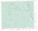
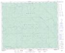
Maps showing Brewster Creek, 42-10-W5, Alberta
Brewster Creek is a River located in 42-10-W5, Alberta and has an elevation of 1040 meters.
- Latitude: 52° 37' 43'' North (decimal: 52.6286111)
- Longitude: 115° 22' 24'' West (decimal: -115.3733332)
- Topography Feature Category: River
- Geographical Feature: Creek
- Canadian Province/Territory: Alberta
- Elevation: 1040 meters
- Location: 42-10-W5
- Atlas of Canada Locator Map: Brewster Creek
- GPS Coordinate Locator Map: Brewster Creek Lat/Long
Brewster Creek NTS Map Sheets