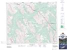
Maps showing Valley of the Hidden Lakes, 29-14-W5, Alberta
Valley of the Hidden Lakes is a Valley located in 29-14-W5, Alberta and has an elevation of 2298 meters.
- Latitude: 51° 28' 44'' North (decimal: 51.4788889)
- Longitude: 115° 54' 43'' West (decimal: -115.9119444)
- Topography Feature Category: Valley
- Geographical Feature: Valley
- Canadian Province/Territory: Alberta
- Elevation: 2298 meters
- Location: 29-14-W5
- Atlas of Canada Locator Map: Valley of the Hidden Lakes
- GPS Coordinate Locator Map: Valley of the Hidden Lakes Lat/Long
Valley of the Hidden Lakes NTS Map Sheets