Maps showing Canon Smith Lake, 71-7-W6, Alberta
Canon Smith Lake is a Lake located in 71-7-W6, Alberta and has an elevation of 734 meters.
- Latitude: 55° 10' 32'' North (decimal: 55.1755555)
- Longitude: 119° 0' 48'' West (decimal: -119.0133333)
- Topography Feature Category: Lake
- Geographical Feature: Lake
- Canadian Province/Territory: Alberta
- Elevation: 734 meters
- Location: 71-7-W6
- Atlas of Canada Locator Map: Canon Smith Lake
- GPS Coordinate Locator Map: Canon Smith Lake Lat/Long
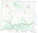
Canon Smith Lake NTS Map Sheets