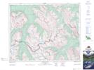
Maps showing Mount Huestis, 33-16-W5, Alberta
Mount Huestis is a Mountain located in 33-16-W5, Alberta and has an elevation of 2749 meters.
- Latitude: 51° 50' 29'' North (decimal: 51.8413888)
- Longitude: 116° 10' 43'' West (decimal: -116.1786110)
- Topography Feature Category: Mountain
- Geographical Feature: Mount
- Canadian Province/Territory: Alberta
- Elevation: 2749 meters
- Location: 33-16-W5
- Atlas of Canada Locator Map: Mount Huestis
- GPS Coordinate Locator Map: Mount Huestis Lat/Long
Mount Huestis NTS Map Sheets