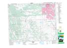
Maps showing Stone Plain, 23-2-W5, Alberta
Stone Plain is a Plain located in 23-2-W5, Alberta and has an elevation of 1157 meters.
- Latitude: 50° 58' 54'' North (decimal: 50.9816667)
- Longitude: 114° 10' 38'' West (decimal: -114.1772222)
- Topography Feature Category: Plain
- Geographical Feature: Plain
- Canadian Province/Territory: Alberta
- Elevation: 1157 meters
- Location: 23-2-W5
- Atlas of Canada Locator Map: Stone Plain
- GPS Coordinate Locator Map: Stone Plain Lat/Long
Stone Plain NTS Map Sheets