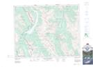
Maps showing Mud Lake, 22-21-10-W5, Alberta
Mud Lake is a Lake located in 22-21-10-W5, Alberta and has an elevation of 1919 meters.
- Latitude: 50° 47' North (decimal: 50.7833333)
- Longitude: 115° 19' West (decimal: -115.3166666)
- Topography Feature Category: Lake
- Geographical Feature: Lake
- Canadian Province/Territory: Alberta
- Elevation: 1919 meters
- Location: 22-21-10-W5
- Atlas of Canada Locator Map: Mud Lake
- GPS Coordinate Locator Map: Mud Lake Lat/Long
Mud Lake NTS Map Sheets