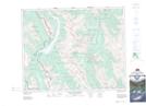
Maps showing Chester Creek, 15-21-10-W5, Alberta
Chester Creek is a River located in 15-21-10-W5, Alberta and has an elevation of 2234 meters.
- Latitude: 50° 48' 41'' North (decimal: 50.8113889)
- Longitude: 115° 16' 35'' West (decimal: -115.2763888)
- Topography Feature Category: River
- Geographical Feature: Creek
- Canadian Province/Territory: Alberta
- Elevation: 2234 meters
- Location: 15-21-10-W5
- Atlas of Canada Locator Map: Chester Creek
- GPS Coordinate Locator Map: Chester Creek Lat/Long
Chester Creek NTS Map Sheets