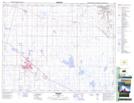
Maps showing Onetree Reservoir, 19-14-W4, Alberta
Onetree Reservoir is a Lake located in 19-14-W4, Alberta and has an elevation of 743 meters.
- Latitude: 50° 36' 28'' North (decimal: 50.6077779)
- Longitude: 111° 49' 38'' West (decimal: -111.8272219)
- Topography Feature Category: Lake
- Geographical Feature: Reservoir
- Canadian Province/Territory: Alberta
- Elevation: 743 meters
- Location: 19-14-W4
- Atlas of Canada Locator Map: Onetree Reservoir
- GPS Coordinate Locator Map: Onetree Reservoir Lat/Long
Onetree Reservoir NTS Map Sheets