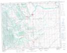
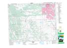
Maps showing Wilson Coulee, 21-1-W5, Alberta
Wilson Coulee is a Valley located in 21-1-W5, Alberta and has an elevation of 1098 meters.
- Latitude: 50° 46' 11'' North (decimal: 50.7697222)
- Longitude: 114° 1' 11'' West (decimal: -114.0197222)
- Topography Feature Category: Valley
- Geographical Feature: Coulee
- Canadian Province/Territory: Alberta
- Elevation: 1098 meters
- Location: 21-1-W5
- Atlas of Canada Locator Map: Wilson Coulee
- GPS Coordinate Locator Map: Wilson Coulee Lat/Long
Wilson Coulee NTS Map Sheets