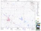
Maps showing Patricia, 13-20-13-W4, Alberta
Patricia is a Unincorporated area located in 13-20-13-W4, Alberta and has an elevation of 731 meters.
- Latitude: 50° 41' 58'' North (decimal: 50.6994444)
- Longitude: 111° 40' 37'' West (decimal: -111.6769444)
- Topography Feature Category: Unincorporated area
- Geographical Feature: Hamlet
- Canadian Province/Territory: Alberta
- Elevation: 731 meters
- Location: 13-20-13-W4
- Atlas of Canada Locator Map: Patricia
- GPS Coordinate Locator Map: Patricia Lat/Long
Patricia NTS Map Sheets