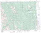
Maps showing Allen Bill Pond, 30-22-5-W5, Alberta
Allen Bill Pond is a Lake located in 30-22-5-W5, Alberta.
- Latitude: 50° 54' 4'' North (decimal: 50.9011110)
- Longitude: 114° 41' 11'' West (decimal: -114.6863888)
- Topography Feature Category: Lake
- Geographical Feature: Pond
- Canadian Province/Territory: Alberta
- Location: 30-22-5-W5
- Atlas of Canada Locator Map: Allen Bill Pond
- GPS Coordinate Locator Map: Allen Bill Pond Lat/Long
Allen Bill Pond NTS Map Sheets