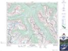
Maps showing David Thompson Creek, 29-33-20-W5, Alberta
David Thompson Creek is a River located in 29-33-20-W5, Alberta.
- Latitude: 51° 50' 46'' North (decimal: 51.8461000)
- Longitude: 116° 47' 39'' West (decimal: -116.7941998)
- Topography Feature Category: River
- Geographical Feature: Creek
- Canadian Province/Territory: Alberta
- Location: 29-33-20-W5
- Atlas of Canada Locator Map: David Thompson Creek
- GPS Coordinate Locator Map: David Thompson Creek Lat/Long
David Thompson Creek NTS Map Sheets