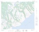
Maps showing Barge Bay Brook, Newfoundland and Labrador
Barge Bay Brook is a River located in Newfoundland and Labrador.
- Latitude: 51° 48' 35'' North (decimal: 51.8096549)
- Longitude: 56° 12' 41'' West (decimal: -56.2112668)
- Topography Feature Category: River
- Geographical Feature: Brook
- Canadian Province/Territory: Newfoundland and Labrador
- Atlas of Canada Locator Map: Barge Bay Brook
- GPS Coordinate Locator Map: Barge Bay Brook Lat/Long
Barge Bay Brook NTS Map Sheets