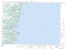
Maps showing Bauline East, Newfoundland and Labrador
Bauline East is a Unincorporated area located in Newfoundland and Labrador and has an elevation of 19 meters.
- Latitude: 47° 10' 46'' North (decimal: 47.1794099)
- Longitude: 52° 50' 44'' West (decimal: -52.8454799)
- Topography Feature Category: Unincorporated area
- Geographical Feature: Locality
- Canadian Province/Territory: Newfoundland and Labrador
- Elevation: 19 meters
- Atlas of Canada Locator Map: Bauline East
- GPS Coordinate Locator Map: Bauline East Lat/Long
Bauline East NTS Map Sheets