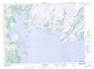
Maps showing Beach Point, Newfoundland and Labrador
Beach Point is a Cape located in Newfoundland and Labrador and has an elevation of 15 meters.
- Latitude: 47° 31' 39'' North (decimal: 47.5274998)
- Longitude: 55° 24' 33'' West (decimal: -55.4091666)
- Topography Feature Category: Cape
- Geographical Feature: Point
- Canadian Province/Territory: Newfoundland and Labrador
- Elevation: 15 meters
- Atlas of Canada Locator Map: Beach Point
- GPS Coordinate Locator Map: Beach Point Lat/Long
Beach Point NTS Map Sheets