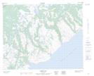
Maps showing Black Bay Pond, Newfoundland and Labrador
Black Bay Pond is a Lake located in Newfoundland and Labrador.
- Latitude: 51° 48' 0'' North (decimal: 51.8000525)
- Longitude: 56° 23' 56'' West (decimal: -56.3990151)
- Topography Feature Category: Lake
- Geographical Feature: Pond
- Canadian Province/Territory: Newfoundland and Labrador
- Atlas of Canada Locator Map: Black Bay Pond
- GPS Coordinate Locator Map: Black Bay Pond Lat/Long
Black Bay Pond NTS Map Sheets