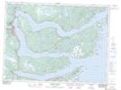
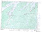
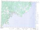
Maps showing British Harbour, Newfoundland and Labrador
British Harbour is a Bay located in Newfoundland and Labrador and has an elevation of 17 meters.
- Latitude: 48° 15' 19'' North (decimal: 48.2552777)
- Longitude: 53° 30' 13'' West (decimal: -53.5036111)
- Topography Feature Category: Bay
- Geographical Feature: Harbour
- Canadian Province/Territory: Newfoundland and Labrador
- Elevation: 17 meters
- Atlas of Canada Locator Map: British Harbour
- GPS Coordinate Locator Map: British Harbour Lat/Long
British Harbour NTS Map Sheets