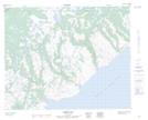
Maps showing Chateau Ponds, Newfoundland and Labrador
Chateau Ponds is a Lake located in Newfoundland and Labrador.
- Latitude: 51° 59' 32'' North (decimal: 51.9922705)
- Longitude: 56° 11' 58'' West (decimal: -56.1994767)
- Topography Feature Category: Lake
- Geographical Feature: Ponds
- Canadian Province/Territory: Newfoundland and Labrador
- Atlas of Canada Locator Map: Chateau Ponds
- GPS Coordinate Locator Map: Chateau Ponds Lat/Long
Chateau Ponds NTS Map Sheets