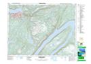
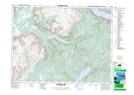
Maps showing Corner Brook, Humber East; Humber West, Newfoundland and Labrador
Corner Brook is a City located in Humber East; Humber West, Newfoundland and Labrador and has an elevation of 33 meters.
- Latitude: 48° 56' 28'' North (decimal: 48.9411111)
- Longitude: 57° 58' 13'' West (decimal: -57.9702776)
- Topography Feature Category: City
- Geographical Feature: City
- Canadian Province/Territory: Newfoundland and Labrador
- Elevation: 33 meters
- Location: Humber East; Humber West
- Atlas of Canada Locator Map: Corner Brook
- GPS Coordinate Locator Map: Corner Brook Lat/Long
Corner Brook NTS Map Sheets