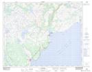
Maps showing Country Cat Pond, Eagle River, Newfoundland and Labrador
Country Cat Pond is a Lake located in Eagle River, Newfoundland and Labrador and has an elevation of 128 meters.
- Latitude: 51° 44' 1'' North (decimal: 51.7336300)
- Longitude: 56° 32' 35'' West (decimal: -56.5429300)
- Topography Feature Category: Lake
- Geographical Feature: Pond
- Canadian Province/Territory: Newfoundland and Labrador
- Elevation: 128 meters
- Location: Eagle River
- Atlas of Canada Locator Map: Country Cat Pond
- GPS Coordinate Locator Map: Country Cat Pond Lat/Long
Country Cat Pond NTS Map Sheets