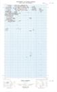
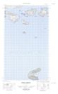
Maps showing Edwards Harbour, Newfoundland and Labrador
Edwards Harbour is a Bay located in Newfoundland and Labrador.
- Latitude: 54° 27' 56'' North (decimal: 54.4656819)
- Longitude: 57° 14' 43'' West (decimal: -57.2453606)
- Topography Feature Category: Bay
- Geographical Feature: Harbour
- Canadian Province/Territory: Newfoundland and Labrador
- Atlas of Canada Locator Map: Edwards Harbour
- GPS Coordinate Locator Map: Edwards Harbour Lat/Long
Edwards Harbour NTS Map Sheets