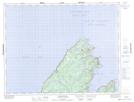
Maps showing Fleur de Lys, Baie Verte-White Bay, Newfoundland and Labrador
Fleur de Lys is a Town located in Baie Verte-White Bay, Newfoundland and Labrador and has an elevation of 33 meters.
- Latitude: 50° 7' 59'' North (decimal: 50.1329250)
- Longitude: 56° 9' 25'' West (decimal: -56.1570194)
- Topography Feature Category: Town
- Geographical Feature: Town
- Canadian Province/Territory: Newfoundland and Labrador
- Elevation: 33 meters
- Location: Baie Verte-White Bay
- Atlas of Canada Locator Map: Fleur de Lys
- GPS Coordinate Locator Map: Fleur de Lys Lat/Long
Fleur de Lys NTS Map Sheets