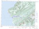
Maps showing Grebes Head, Newfoundland and Labrador
Grebes Head is a Cape located in Newfoundland and Labrador and has an elevation of 25 meters.
- Latitude: 47° 55' 39'' North (decimal: 47.9275000)
- Longitude: 59° 22' 42'' West (decimal: -59.3783333)
- Topography Feature Category: Cape
- Geographical Feature: Head
- Canadian Province/Territory: Newfoundland and Labrador
- Elevation: 25 meters
- Atlas of Canada Locator Map: Grebes Head
- GPS Coordinate Locator Map: Grebes Head Lat/Long
Grebes Head NTS Map Sheets