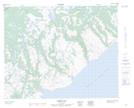
Maps showing Green Bay Point, Eagle River, Newfoundland and Labrador
Green Bay Point is a Cape located in Eagle River, Newfoundland and Labrador.
- Latitude: 51° 51' 13'' North (decimal: 51.8536215)
- Longitude: 56° 5' 50'' West (decimal: -56.0970983)
- Topography Feature Category: Cape
- Geographical Feature: Point
- Canadian Province/Territory: Newfoundland and Labrador
- Location: Eagle River
- Atlas of Canada Locator Map: Green Bay Point
- GPS Coordinate Locator Map: Green Bay Point Lat/Long
Green Bay Point NTS Map Sheets