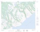
Maps showing Gun Point, Eagle River, Newfoundland and Labrador
Gun Point is a Cape located in Eagle River, Newfoundland and Labrador.
- Latitude: 51° 47' 28'' North (decimal: 51.7911480)
- Longitude: 56° 12' 12'' West (decimal: -56.2033813)
- Topography Feature Category: Cape
- Geographical Feature: Point
- Canadian Province/Territory: Newfoundland and Labrador
- Location: Eagle River
- Atlas of Canada Locator Map: Gun Point
- GPS Coordinate Locator Map: Gun Point Lat/Long
Gun Point NTS Map Sheets