Maps showing Parsons Harbour, Newfoundland and Labrador
Parsons Harbour is a Unincorporated area located in Newfoundland and Labrador.
- Latitude: 47° 35' 59'' North (decimal: 47.5997222)
- Longitude: 56° 39' 12'' West (decimal: -56.6533333)
- Topography Feature Category: Unincorporated area
- Geographical Feature: Vacated or Seasonal Settlement
- Canadian Province/Territory: Newfoundland and Labrador
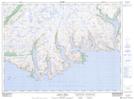
- Atlas of Canada Locator Map: Parsons Harbour
- GPS Coordinate Locator Map: Parsons Harbour Lat/Long
Parsons Harbour NTS Map Sheets