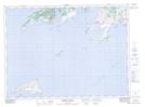
Maps showing Thompson Beach, Newfoundland and Labrador
Thompson Beach is a Beach located in Newfoundland and Labrador and has an elevation of 18 meters.
- Latitude: 47° 28' 46'' North (decimal: 47.4794444)
- Longitude: 55° 47' 41'' West (decimal: -55.7947222)
- Topography Feature Category: Beach
- Geographical Feature: Beach
- Canadian Province/Territory: Newfoundland and Labrador
- Elevation: 18 meters
- Atlas of Canada Locator Map: Thompson Beach
- GPS Coordinate Locator Map: Thompson Beach Lat/Long
Thompson Beach NTS Map Sheets